DJI MATRICE 350 RTK
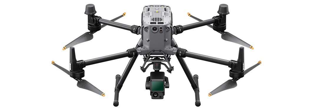
MATRICE 350 RTK
WITH P1 CAMERA OR L2 LIDAR
With a variety of payloads, the M350 can perform a multitude of roles, but it really excels at making complex geospatial workflows, like LIDAR, much more accessible and achievable.
When your project is large or difficult and a <2kg photogrammetry drone won’t cut it, this is the system to compare all others against.
EFFORTLESSLY POWERFUL FLIGHT PERFORMANCE
Built tough, the Matrice 350 RTK features powerful propulsion, enhanced protection rating, and excellent flight performance, allowing it to effortlessly tackle a wide variety of challenges.
POWERFUL PAYLOADS
The Matrice 350 RTK is capable of supporting a single downward gimbal, dual downward gimbals, and a single upward gimbal, allowing it to carry up to three payloads at once. With an E-Port open interface and a maximum payload capacity of 2.7 kg, it is designed to meet the demands of various operational scenarios such as public safety, inspection, and mapping.
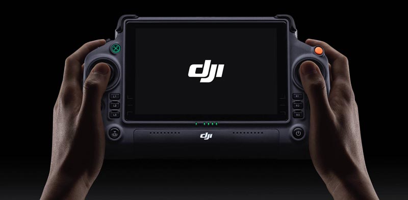
DJI RC Plus
Equipped with a 7-inch high-bright screen, DJI RC Plus supports Dual Operator Mode and comes with a standard WB37 external battery that offers an operating time of up to six hours, meeting various operation needs.
O3 Enterprise Transmission
Matrice 350 RTK adopts DJI O3 Enterprise Transmission Supports triple-channel 1080p HD live feeds, [5] and a max transmission distance of 20 km. [6] Both the aircraft and the remote controller have a four-antenna transceiver system, which can intelligently select the two optimal antennas to transmit signals, while the four antennas receive signals simultaneously. In this way, anti-interference capabilities are significantly improved, and transmission stability is optimized.
Built Ready for Harsh Environments
IP54 rated, [2] DJI RC Plus is dustproof and waterproof to operate reliably in bad weather. The operating temperature is -20° to 50° C (-4° to 122° F), supporting around-the-clock operation even in severely hot or cold environments.

Specs
Aircraft
Dimensions (unfolded, without propellers)
Dimensions (folded, with propellers)
Diagonal Wheelbase
Weight (with single downward gimbal)
Without batteries: Approx. 3.77 kg
With two TB65 batteries: Approx. 6.47 kg
Single Gimbal Damper’s Max Payload
Max Takeoff Weight
Operating Frequency
2.4000-2.4835 GHz
5.150-5.250 GHz (CE: 5.170-5.250 GHz)
5.725-5.850 GHz
Transmitter Power (EIRP)
2.4000-2.4835 GHz:
< 33 dBm (FCC)
< 20 dBm (CE/SRRC/MIC)
5.150-5.250 GHz (CE: 5.170-5.250 GHz):
< 23 dBm (CE)
5.725-5.850 GHz:
< 33 dBm (FCC/SRRC)
< 14 dBm (CE)
Hovering Accuracy (with moderate or no wind)
Vertical:
±0.1 m (with vision positioning)
±0.5 m (with GNSS positioning)
±0.1 m (with RTK positioning)
Horizontal:
±0.3 m (with vision positioning)
±1.5 m (with GNSS positioning)
±0.1 m (with RTK positioning)
RTK Positioning Accuracy (RTK FIX)
1.5 cm + 1 ppm (vertical)
Max Angular Velocity
Yaw: 100°/s
Max Pitch Angle
When in N mode and with the forward vision system enabled: 25°
Max Ascent Speed
Max Descent Speed (vertical)
Max Tilted Descent Speed
Max Horizontal Speed
Max Flight Altitude
5000 m
When using the 2110s propellers and with the takeoff weight ≤ 7.4 kg
7000 m
When using the 2112 High-Altitude Low-Noise Propellers and with the takeoff weight ≤ 7.2 kg
Max Wind Speed Resistance
Max Flight Time
Supported DJI Gimbals
Third-Party Payload
Supported Gimbal Configurations
Single upward gimbal
Dual downward gimbals
Single downward gimbal + single upward gimbal
Dual downward gimbals + single upward gimbal
Ingress Protection Rating
The IP rating is not permanently effective and may decrease due to product wear and tear.
Global Navigation Satellite System
Operating Temperature
Class
Remote Controller
Screen
Weight
Approx. 1.42 kg (with WB37 battery)
Global Navigation Satellite System
Built-in Battery
Charging Type: Use the battery station or USB-C fast charger with a max power of 65 W (max voltage of 20 V).
Charging Time: 2 hours
Chemical System: LiNiCoAlO2
External Battery (WB37 Intelligent Battery)
Voltage: 7.6 V
Type: Li-ion
Energy: 37.39 Wh
Chemical System: LiCoO2
Ingress Protection Rating
Operating Time
Built-in Battery + External Battery: approx. 6 hours
Operating Temperature
Operating Frequency
5.725-5.850 GHz
Transmitter Power (EIRP)
2.4000-2.4835 GHz:
< 33 dBm (FCC)
< 20 dBm (CE/SRRC/MIC)
5.725-5.850 GHz:
< 33 dBm (FCC)
< 14 dBm (CE)
< 23 dBm (SRRC)
Wi-Fi Protocol
Wi-Fi Operating Frequency
5.150-5.250 GHz
5.725-5.850 GHz
Bluetooth Protocol
Bluetooth Operating Frequency
Video Transmission
Video Transmission System
Antenna
Max Transmission Distance (unobstructed, free of interference)
8 km (CE/SRRC/MIC)
Max Transmission Distance (with interference)
Low Interference and Obstructed by Buildings: approx. 0-0.5 km
Low Interference and Obstructed by Trees: approx. 0.5-3 km
Strong Interference and Unobstructed: urban landscape, approx. 1.5-3 km
Medium Interference and Unobstructed: suburban landscape, approx. 3-9 km
Low Interference and Unobstructed: suburb/seaside, approx. 9-20 km
Vision System
Obstacle Sensing Range
Upward/Downward: 0.6-30 m
FOV
Left/Right/Upward: 75° (horizontal), 60° (vertical)
Operating Environment
Infrared Sensing System
Obstacle Sensing Range
FOV
Operating Environment
LED Auxiliary Light
Effective Illumination Distance
Illumination Type
FPV Camera
Resolution
FOV
Frame Rate
Intelligent Flight Battery
Model
Capacity
Voltage
Type
Energy
Weight
Operating Temperature
Ideal Storage Temperature
Charging Temperature
When the ambient temperature is below 5° C (41° F), the battery will trigger the auto-heating function. Charging at low temperatures may reduce battery life. It is recommended to charge at 15° to 35° C (59° to 95° F).
Charging Time
With a 110V power supply, it takes approximately 70 minutes to fully charge two TB65 Intelligent Flight Batteries and approximately 40 minutes to charge them from 20% to 90%.
Intelligent Battery Station
Dimensions
Net Weight
Compatible Stored Items
Four WB37 Intelligent Batteries
Input Voltage
220-240 VAC, 50-60 Hz
Max Input Power
Output Power
220-240 V: 992 W
Operating Temperature
Footnotes
The terms HDMI, HDMI High-Definition Multimedia Interface, HDMI Trade dress and the HDMI Logos are trademarks or registered trademarks of HDMI Licensing Administrator, Inc.